John Paul Mbuthia
A spatial data analyst student with a passion in spatial data science, who is interested in data visualization and analytics to create compelling stories.
Currently looking for an attachment.
View My LinkedIn Profile
Resume
Portfolio
Machine Learning/ Spatial Analytics With python
Predicting and Estimating Multidimensional Child Poverty in Kenya
This research focuses on estimating and predicting multidimensional child poverty in Kenya. This study uses the 2020 survey data of Kenya to estimate multidimensional child poverty in the country. After having the target variables and estimations, random forest regressor model was used to predict multidimensional child poverty in Kenya. Highly accurate multidimensional child poverty maps are then created, which show the estimations and the predictions.
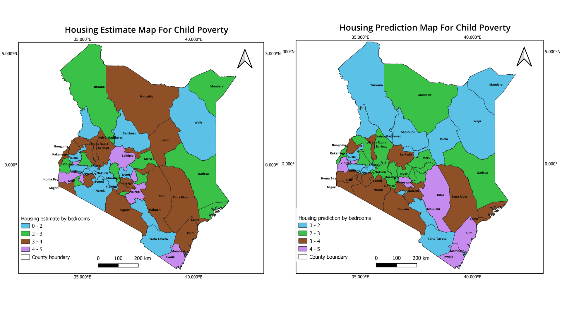
Skill used: Python, Geemap, QGIS, Random Forest & Linear Regressions
Eurosat Land Use and Land Cover Classification Using Deep Learning
Human activities on earth have caused rapid changes on land cover over the last decades. Monitoring land cover changes is important to understand the relationship between man and nature to provide decision makers with relevant information. This project I attempted to find high accuracy in classifying Eurosat satellite images using deep learning algorithms.
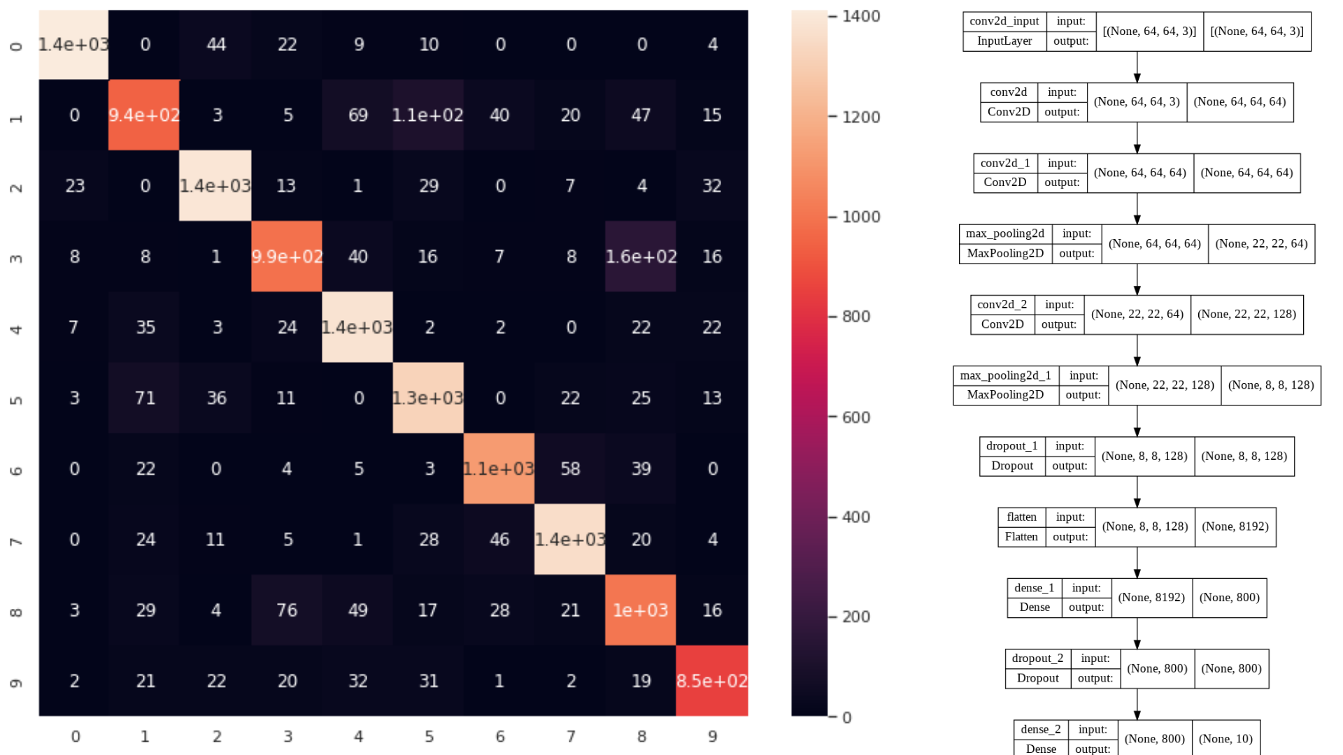
Skill used: Python, Keras, CNN, VGG16
Identifying and Classifying Informal Settlements in Argentina
In the past few decades urbanization has been bringing a large number of new residents to cities. This rapid urban expansion caused the inadequate developments of infrastructure, such as affordable housing, public transport and utilities. Informal settlements known as slums emerged which had inadequate infrastructure and insufficient living areas inhabited by low-income urban residents.
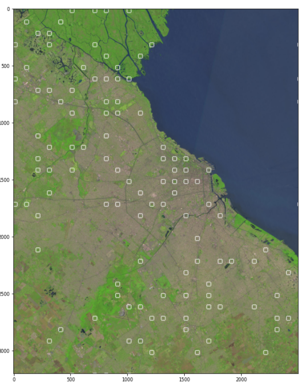
Skill used: Python, SVM, CNN, ResNET
Machine Learning/ Spatial Analytics with R
Land Use Land Cover Classification with R
Land plays an important role in the socioeconomic conditions of humans. Baringo county is known to have two lakes, Lake Baringo at 130 km2, and Lake Bogoria an alkaline lake with an area of 34 km2. Despite having two lakes in one county, Baringo also has vast large tracts of land which are forests, farmlands, grasslands, built-up areas, and other lands. Using remote sensing technology helped by the statistical language of R, new land cover classes of Baringo have been created using the Intergovernmental Panel on Climate Change (IPCC) land cover classes which are wetlands, farmlands, grasslands, forests, built up areas and other lands. These classes will help outline area changes which will be in hectares of land cover of Baringo county over a 3-decade span. This project helps in detecting changes in land cover and also contributes significantly to the mitigation of climate change, including the promotion of sustainable management of forests, water bodies, and terrestrial ecosystems.
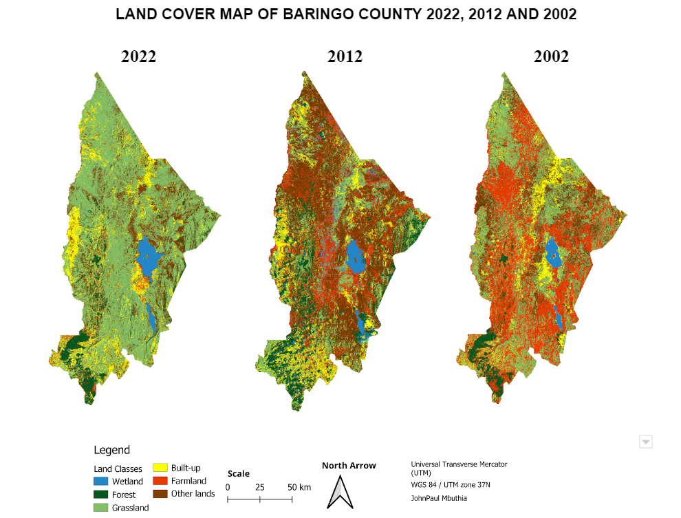
Skill used: R, Random Forest Model, SVM Model
Space Time Prediction - Re-balancing Bike Demands
A bike share program is a shared transport service in which bicycles are made available for shared use to individuals on a short term basis for a price. This project developed a method of predicting bike share trips in Manhattan Island, with emphasis on bike share demand. This document outlines the motivation for this project, exploratory analysis, feature engineering and model building.
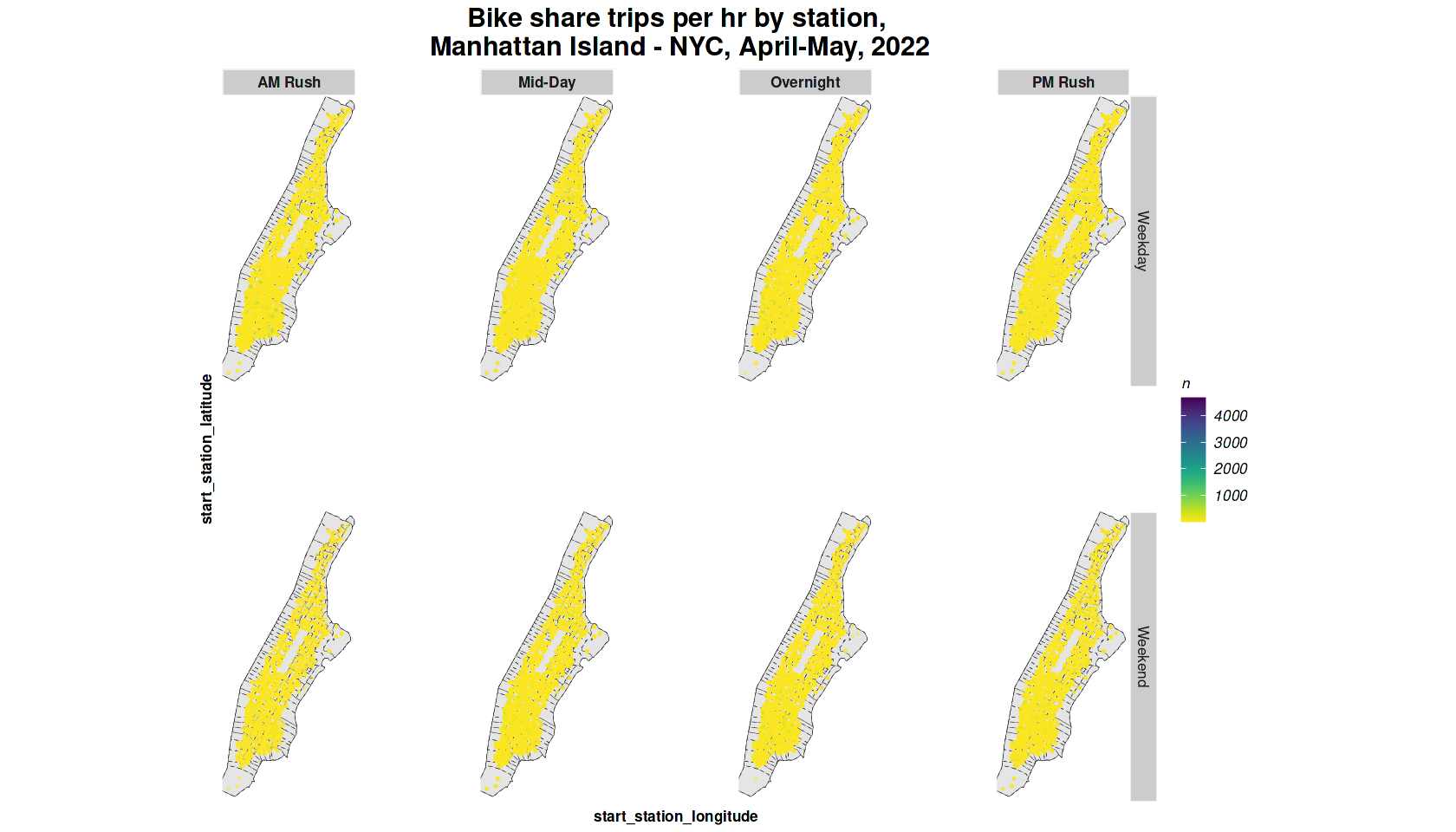
Skill used: R, Linear Regressions
Spatial Analytics with Google Earth Engine
High Carbon Stock Approach and Analysis of Mt. Kenya Forest, Cherangany Hills and Aberdare Forest
High carbon stock areas refer to landscapes or ecosystems that store large amounts of carbon in their vegetation, soil, and other organic matter. These areas are critical for mitigating climate change because they play a crucial role in absorbing and storing carbon dioxide from the atmosphere, which helps to reduce the concentration of greenhouse gases in the atmosphere. This study will mainly focus on identifying viable forest patches that are of the most conservation importance. These efforts will aim at promoting the sustainable use of forest resources while protecting the high carbon stock and other ecosystem services provided by these forests.
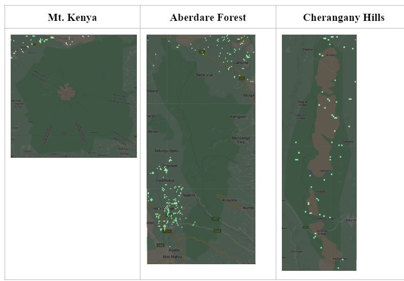
Skill used: Google Earth Engine
Mapping Lake Naivasha Expansion Using Google Earth Engine
Lake Naivasha is expanding and it has enormous implications for the regions surrounding it. River Malewa and Gilgil river flow into the Lake and carry large sediments into the lake in the rainy season. Using Google Earth Engine I mapped and calculated the expansion of the lake with its environmental effects.
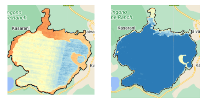
Skill used: Python, geemap, ee
Skills and technical expertise
- Geospatial Analytics: ESRI GIS Software Suite (raster and vector), ArcPy, Google Earth Engine, Environmental Modeling, QGIS, ERDAS
- Programming Languages: R, Python, JavaScript, HTML, ReactJS, Git, OpenStreetMaps
- Statistical Analysis: Machine learning (supervised and unsupervised), Predictive Modeling in R, Spatial Statistics
- Data Visualization: HTML/CSS, Mapbox, Carto, ArcGIS API, Adobe Suite, Seaborn, Matplotlib, Altair (Python)
- Web Development: Carto, JavaScript, Python for Web Development (Django, folium, flask)
- Satellite Imagery/ Remote Sensing: ArcGIS Spatial Analytics Toolbox, Python and R image processing
- Environmental Science: Climate Change Concepts
Page template forked from evanca